
The Carpathians are a mountain range, part of which is located in Ukraine. The mountains are popular with travelers and hikers of all skill levels and experience levels. Hiking in the Ukrainian Carpathians is a popular tourist destination, as the region is beautiful year-round. Here you can see towering mountains and numerous waterfalls, sample delicious cuisine, visit a ski resort, ancient fortresses, and much more. The Ukrainian Carpathians are an ideal option for hikers of all ages and interests.
Hiking in the Carpathians — Climate
The Ukrainian Carpathians have a moderate continental climate, making this mountain range technically traversable year-round. The Carpathian climate is the wettest in the country, but there are also favorable conditions for hiking and climbing:
- Summer in the mountains is hot, with moderate precipitation. However, summer rains are relatively short and warm. Heavy rainfall is very rare.
- Autumn in the Carpathians is stable and dry, and hiking is recommended during the first months of the season.
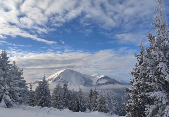
- Winters in these mountains are mild and snowy. On average, snowstorms occur no more than 20 days per year.
- Spring is quite wet, characterized by mostly unstable weather. However, the slopes still have sufficient grip at this time, so this season is worth considering if you plan to ski.
The most unfavorable months for hiking in the Carpathians are:
- April — floods, very unstable weather conditions;
- November — fog, snowfalls, high humidity, mostly unstable weather conditions.
Hiking in the Carpathian Mountains – Choosing the Season
The hiking season in the Ukrainian Carpathians begins in spring, beginning in May, when the weather becomes more stable and precipitation decreases. Days are mostly sunny, the chance of snowfall is minimal, and temperatures can reach 15°C.
Summer in the Carpathians offers the most comfortable conditions for hiking enthusiasts. June is characterized by mostly dry weather, with temperatures around 20°C (+10°C in the mountains). In July, temperatures rise to 25°C, and most precipitation falls during this month.
August is the ideal time for all trekking enthusiasts:
- The weather is mostly dry, with no extreme heat;
- Wild berries and mushrooms are ubiquitous along the routes;
- The temperature remains at a comfortable level of around 20°C.
In autumn, towards the end of September, the mountains are covered in golden hues, and temperatures hover around 15°C, although morning frosts can occur. October is best for leisurely hikes, allowing you to appreciate the beauty of the mists at sunset or sunrise. Winter begins in the Ukrainian Carpathians in November, so hiking is not the best option from this month onwards due to heavy fog and mostly rainy weather.
By early December, the climate in the Carpathians stabilizes, the snow density increases, and the sun peeks out from behind the clouds slightly more frequently. This month marks the beginning of the active ski season, with freeriding and backcountry activities in full swing. Extreme sports enthusiasts and winter trekkers are recommended to visit January, but be prepared for significant cold snaps. Nighttime temperatures can reach -15°C. The weather remains stable until mid-February, but thaws become more frequent towards the end of the month. This increases the risk of avalanches, so even experienced trekkers are advised not to go without a guide.
Hiking in the Carpathians: Choosing a Program
A tour of the Ukrainian Carpathians can offer a wealth of vibrant emotions and unforgettable moments. However, to achieve this, you need to choose the right leisure activity. These can be roughly divided into three categories:
- Hiking in the Carpathians. The goal is to cover a route through rugged terrain on foot.
- Climbing. This involves conquering one or more mountain peaks.
- Extreme sports. Rafting, freeriding, and many other activities are designed to give program participants vibrant emotions and unforgettable experiences.
In all cases, routes are rated according to a specific classification, depending on their difficulty and the requirements for expedition participants. Tours are available for both beginners and experts.
Hiking in the Carpathians: Chornohora Ridge, Gorgany, Synevyr
If you’re interested in the Ukrainian Carpathians, there are many hiking tours available:
- Along the Chornohora Ridge. The tour route is not the easiest, but it is very scenic. The group will pass through the highest peaks of the Carpathians—Mounts Petros, Hoverla, Brebeneskul, Pop Ivan, and others. The route includes long climbs and occasional bad weather.

- Along the Chornohora Ridge (winter) + ascent of Petros. This moderately challenging hike allows tourists not only to see the Ukrainian Carpathians in winter but also to gain valuable skills. During the tour, expedition participants will learn how to use crampons, use an ice axe, set up winter bivouacs, and dig snow caves. Nighttime temperatures can drop to -30°C, which, coupled with strong cold winds, creates quite extreme conditions for the group.

- Across the Gorgany Mountains. This mountain range can rightfully be called the “wild Carpathians,” as trails are virtually nonexistent, and people are rarely seen in the meadows, and only in the summer. During the hike, expedition participants will ascend to the range’s panoramic peaks, from where they can admire and appreciate the beauty of the Chornohora Range, Svydovets, Igrovets, and other peaks.

- To Lake Synevyr. The Synevyr waters are surrounded by dense forest, lending the lake a sense of mystery and charm. A hiking trip to the Carpathians can include conquering various mountains, including Koretvyna, Popadya, Grofa, and Moloda.

Hiking in the Carpathians – climbing Mounts Hoverla and Petros
Some of the highest peaks of the Ukrainian Carpathians are:
- Mount Petros – 2020.2 m;
- the highest point in Ukraine, Mount Hoverla – 2061 m.
Climbing these peaks is possible in both summer and winter. Despite its high altitude, conquering Hoverla is quite easy due to its gentle slope and convenient roads. Afterward, climb Mount Petros, which is only slightly lower in altitude than Hoverla but offers a completely different experience due to its steeper climb.
The winter climbing program for Petros and Hoverla is a preparation for more challenging hikes and ascents. This tour will allow you to expand your knowledge of:
- Rules of conduct in the mountains during winter;
- use of mountaineering equipment;
- survival methods in extreme conditions;
- avalanche safety, including methods for identifying avalanche-prone areas;
- organization of overnight stays during winter climbing;
- tactics for winter mountain hiking.
In addition, the tour will be of interest to those who want to enjoy the beautiful view of the snow-covered Ukrainian Carpathians.
Active recreation in the Carpathians: rafting, freeriding, backcountry skiing
Rafting—sportsmanship on mountain rivers in inflatable boats (rafts)—is common in the Carpathians. Rafting often takes place on the Cheremosh River. The rafting is rated at difficulty levels 2 and 3. The first category is suitable for amateurs, as the route features straightforward rapids with clear, wide passages between the rocks. The third category route often features chaotic, high waves and numerous rocks. This type of rafting is very exciting, but quite challenging, and capsizing is almost inevitable. The best time to raft is in the spring—in April or during the May holidays.

Freeriding is a form of snowboarding or skiing outside of groomed pistes. It’s a great choice if you’re confident on skis and want to add something new and exciting to your skiing routine. For both amateurs and experienced skiers, freeriding with a guide is recommended for maximum safety.
Backcountry skiing is the practice of hiking to peaks where there are no mechanical means of ascent, followed by descent on skis or snowboards. Backcountry skiing is a form of freeriding, but with a greater emphasis on tourism during the ascent, rather than simply the descent down unprepared trails.

Freeriding and backcountry skiing take place primarily in winter, from late November to mid-April. The most popular location for skiing is Ukraine’s highest ski resort, Dragobrat. Situated at an altitude of 1,300-1,700 meters, it’s located nearby, along with the country’s largest ski resort, Bukovel, at an altitude of 920-1,372 meters.
Hiking in the Carpathians: Famous Places and Attractions
The Ukrainian Carpathians are home to many famous sites, cultural monuments, and more. Here are a few:
- Castle Saint Miklos in Chinadievo. This castle was built in the early 15th century. In 2001, the building was restored and now hosts musical concerts and exhibitions of historical paintings.
- Dovbush Rocks in the village of Bubnyshche. Near the caves here, you can find the remains of fortifications from the 9th to 13th centuries: benches, stairs, ramparts, and loopholes. From the top of the rocks, a stunning panorama opens onto the Ukrainian Carpathians, as well as two mountains—Parashka and Klyuch.
- Lake Synevyr. It reaches 24 meters in depth and covers approximately 7 hectares. This place is shrouded in legends and mysteries, which tourists can try to unravel for themselves, for example, by hiking to Lake Synevyr.
These are just a few of the attractions the Ukrainian Carpathians have to offer travelers. There are dozens of them, including ancient castles, churches, monasteries, caves, lakes, and much more.
Hiking in the Carpathians – Preparing for the Tour
Before a hiking trip, all group members must thoroughly prepare for the event, as its success depends on it. This includes not only the necessary equipment but also physical and mental preparation. Requirements vary depending on the tour, but basic training before long hikes is recommended for all expedition members.
You can learn more about the training in the “Preparation” section. If you have any questions, please call the contact numbers on the website.
The benefits of hiking in the Carpathians with ExtremeGuide.Pro
ExtremeGuide is a team of professionals with 17 years of experience organizing and executing travel trips, active recreation, tours, excursions, and more. Safety is our top priority, so we always have the following on hand:
- GPS navigators;
- satellite, mobile, and radio communications;
- group first aid kit;
- professional assessment of risks encountered during the route;
- contact with local emergency services.
Each guide strives to create and maintain a friendly and positive atmosphere for tour participants. Furthermore, programs are categorized by difficulty level and the number of requirements for participants. Completing easier routes will teach you valuable skills, and at the end of the tour, you’ll receive certificates and souvenirs.